01 · INGEST
Real NASA + ESA data
Mars MOLA, Moon LOLA, Mercury MESSENGER, Ceres Dawn; Copernicus GLO-30 for Earth — no API key.
A provenance-first instrument that compares planetary and Earth terrain at a shared metric scale across five worlds, exposes what cannot transfer, and refuses to fake a winner. Its sharpest result is a claim it disproved — its own.
Finding a landscape that looks like Mars takes a search box. Designing a terrestrial test whose result legitimately transfers to a Mars decision takes measurable requirements, a shared spatial support, and an honest account of every gap.
Each area of interest is warped to its own local azimuthal-equidistant metric grid using the correct body — Mars on a 3,396,190 m sphere, the Moon, Mercury, Ceres, and Earth on WGS84 — so slope and relief are measured in true, comparable metres. Candidates are ranked by Pareto dominance across independent descriptor “lenses”, never a composite score; a tie is a valid result.
Mars MOLA, Moon LOLA, Mercury MESSENGER, Ceres Dawn; Copernicus GLO-30 for Earth — no API key.
The correct body radius, true metres — not a shared-degree hack.
Water/sentinel masking, flat-tile blocking, and a comparability gate that rejects a cell whose footprints are not truly matched.
Six analytical lenses — five default, one optional hydro lens; tie, indeterminate and blocked are first-class outcomes, not failures.
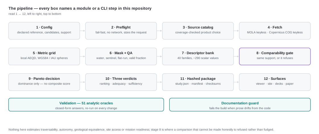
Roughly thirty cited descriptor families, each defined, unit-bearing, and traceable to a source through the evidence graph. None is collapsed into a single “Mars-likeness” number.
It would have been easy to stop at the first answer. Instead we tested it with rules frozen before the data were seen — and it did not survive. So we measured why.
Mars MOLA versus real Earth terrains at a common metric support. On the core roughness/relief axes a documented basalt field was the closest match — it looked like an analog the engine had re-identified on its own.
Matched physical footprints, supports at or above MOLA’s effective resolution, held-out plains plus contrast terrains. The engine abstained for all seven references — and Craters was nearest for a cratered highland just as readily as for volcanic plains. Claim withdrawn.
Two smoothness-matched non-volcanic controls, 60 km windows, fresh plains and highlands. A smooth non-volcanic terrain sat on the Pareto front for every confirmatory volcanic plain, while basaltic origin bought nothing — the basalts came forward only for the rough highlands.
One caveat is recorded with the result rather than hidden: v3 is pre-specified but not fully pre-registered — the rules and config were frozen before the data, but the protocol document was committed after the run.
The Moon is the other half of the challenge, so it was run on real NASA Goddard LOLA 5 m/pixel terrain: all six published south-polar candidate regions, screened against the same Earth roster on an exact common grid — 500, 750 and 1000 m cells covering 9 km on every unit, on both bodies. Every site is rough terrain. Across 18 of 18 site × support cells the sole non-dominated Earth candidate was the same: the Nevada Basin & Range. The two smooth non-volcanic terrains that answered for Martian volcanic plains were the worst matches here.
Three things stop that reading as a finding. The candidate is not always close: at
Shackleton rim even the survivor is 70% away on its worst axis, so it is the
least-dissimilar of a weak shortlist — the exact failure mode this project withdrew a claim
over on the Mars side. The three declared axes are not three axes: mean slope and 3×3
relief are the same gradient measured two ways — relief = 2 d·tan(slope)·ρ, with
ρ provably confined to [1, √2] and depending only on the gradient's direction —
checked against the engine's own functions to 4.4e-16 m and confirmed on the panel
at effective rank 1 of 3. And an earlier version of this comparison did not put both
bodies on the same ground at all; that is corrected and rerun, the ordering held, and the
distances moved.
So the conclusion was then attacked rather than defended: 30 counted perturbations — window origin, support jitter, footprints from 3 to 10.5 km, both alternative resampling kernels, edge and extreme-cell masking, DEM noise, tilt and smoothing, descriptor dropout, candidate dropout, one added candidate — declared in a config committed before the run, with the pass rule fixed in advance. It survived 28 of the 30 perturbations: only 18 of 504 site × support cells moved, a cell-level stable fraction of 0.964, verdict ROBUST. The two that reverse are the falsifiable part and are named: a 3 km window changes the survivor, and adding an eighth candidate makes Nevada a co-winner rather than the sole one.
Then the two questions that a ranking always gets mistaken for were answered separately, as first-class outputs. Is any candidate inside the reference's own morphological variability at this scale? — not established, at every cell, because the yardstick fails: where both descriptor bands can be calibrated — 6 of the 18 cells, the six at 500 m — the reference's own self-distance band comes out so wide that it admits at least 4 of 5 other lunar sites, and a band that says adequate to terrain from demonstrably different places has established nothing. At the other 12 there is no relief band at all — the held-out sub-windows do not supply one at 750 or 1000 m — so the verdict there rests on the slope band alone, which also admits at least four of the five. The verdict is the same either way, and it rests on a weaker test at those twelve; the second band is missing rather than wide, and that is stated rather than folded into the sentence above.
Is the evidence enough? — marginal, with the reasons named. And adding those sibling sites as controls produced the least comfortable number on this page: at 18 of 24 site × descriptor statistics the unit nearest a lunar reference is another lunar site, not any of the seven Earth candidates. The ranking is definite at all 18 cells and it is an ordering within the Earth roster — it is not evidence that the roster contains the Moon.
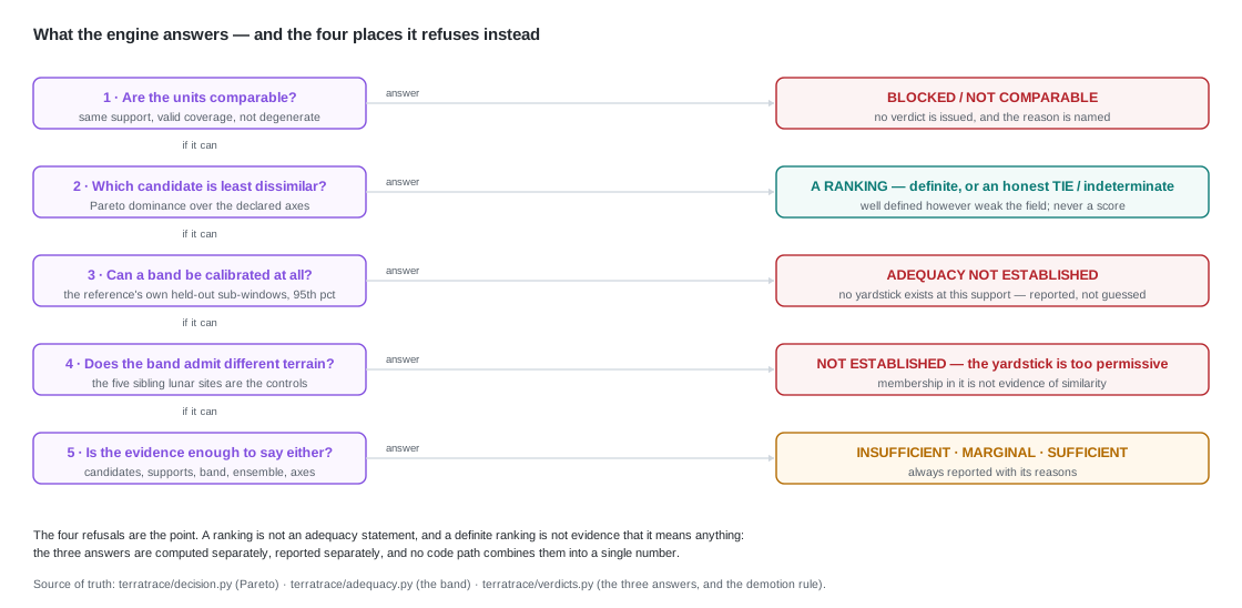
It stays exploratory, not confirmatory: six nearby sites are not six independent tests, and the error-ensemble check is 6 of the 100 published realisations. No base suitability of any kind is claimed — morphology only.
Each result is frozen in a dated protocol, reproducible from one command, and mapped to the evidence that would falsify it. Nothing here claims traversability, geologic equivalence, site access, or mission readiness.
The newest result is a bound on our own headline. The lunar panel's sole non-dominated candidate turns out to be a property of running a Pareto rule over eight units in three dimensions, not evidence about a candidate: a uniformly random fourth axis moves that frontier in 15.90 of 18 cells on average, and no candidate axis in the engine's own bank beats it. An arbitrary coordinate does what a better descriptor does.
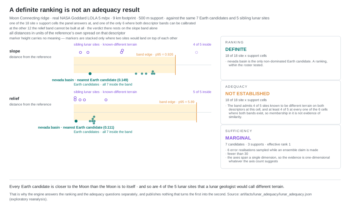
scripts/make_adequacy_figure.py, which refuses to run when that record is absent
rather than drawing an illustrative version.# reproduce the protocol-v3 panel — no API key, no account
python scripts/fetch_earth_candidates.py --config config/matched_footprint_v3.yml --source cog
python scripts/run_matched_benchmark.py --config config/matched_footprint_v3.yml --out artifacts/mf_panel_v3
1044 offline tests and 51 scientific-correctness oracles, deterministic study hashes, a source lock with SHA-256 and citations, and an evidence graph from source to claim. The Earth data path is keyless. Open the live study, read the method, or clone the repository.